
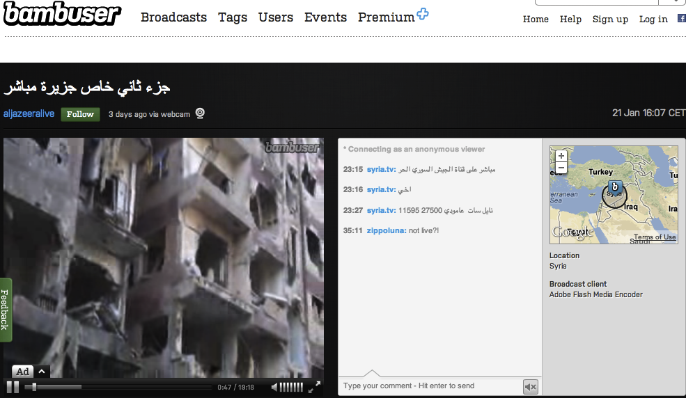
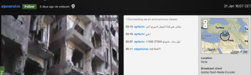
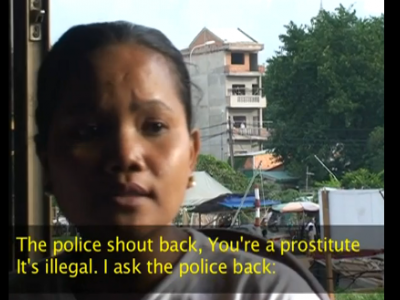
In February 2012, a Syrian citizen videographer known only as Omar began streaming video of the view out the window of his house in Homs. Using a simple webcam and the free online streaming service Bambuser, he was able to capture live images of the conflict erupting in his city.
When military forces bombed an oil pipeline, live footage of the action was picked up by major news outlets including CNN, BBC News and Al Jazeera. It was the first time in history that a user-generated stream was aired live on major TV networks. The message was clear: citizen media must be taken seriously. These images were raw and unfiltered. The Syrian government would later block access to Bambuser as a result of the media attention these videos brought to the conflict.
Streaming content in real-time
Streaming content allows you to broadcast an event in real time to an internet audience. This can take the form of 'sousveillance' or safety monitoring, as when filming a protest. It can also simply serve to broaden your audience by allowing people outside your location to participate actively in your event. It has also been used to bypass censorship in certain cases, by passing from mobile phones directly onto foreign servers.
Why use it?
Some content is rendered pertinent by the depth of its information; other content is rendered pertinent by its immediacy. An increasingly interconnected world has redefined what we consider to be 'fresh' information, and allows us to observe or participate in events happening across the globe in real time.
This has had important ramifications on how we deal with crisis situations like natural disasters. Wireless and mobile technology can plug holes where traditional modes of communication fail.
How can I use it for my campaign?
With a stable internet connection and a device or computer equipped with a camera, it is now relatively easy to start streaming content directly online. Websites such as Qik or Bambuser allow you to stream video to a server, where it is physically saved, allowing real-time access and immediate embedding. With applications such as Yodl you can create a 'personal radio station' via live audio streamed from your phone. Both iCloud for iOS and Google+ for Android now allow real-time photo streaming via an instant syncronisation feature. You can even stream live GPS coordinates using apps like Sensor Data and Find my Friends.
Youtube now has a feature that enables free live streaming for non-profit organisations via their Youtube channels. Once you activate this feature on your account, you simply create a live event and follow the steps. Streaming at multiple resolutions is also possible. For more information, read these support guides here and here.
Security issues
- Remember that information that is used to verify the authenticity of the stream (such as timestamps or location data) can also be used to identify you. Turn off GPS if safety is a concern.
- Be sure you understand what content is being made public and when. Publishing every photo you take to the cloud is not advisable in situations where privacy and anonymity are a concern. Run tests beforehand if necessary.
- Be mindful of protecting those who appear in your footage and think about how they could be negatively impacted if they are identified.
Streaming tips
Streaming from a computer
- If possible, choose a wired (ethernet) connection over a wireless connection, as the former is less susceptible to bandwidth fluctuations.
- Don't trust the bandwidth speeds advertised by the service provider – test the connection yourself using speedtest.net and note down the upload and download speeds. The upload speed is the most important for streaming purposes.
- If possible, minimise the internet activity of other computers on the network. Simultaneous uploads will take a piece out of the optimum bandwidth and slow down or interrupt your stream.
- Set your outgoing stream rate at just below the upload speed. Keep in mind the speed may fluctuate according to the time of day, the number of users on the network, or the server load; so leave yourself plenty of headroom.
- Monitor your own stream using headphones. Do not use external speakers, as this may cause an audio feedback loop if you are streaming within the range of the microphone at the same time.
- Ideally, try to record simultaneously onto a local source – either to tape or memory card (if using an external camera) or directly to the hard drive (if using a webcam). Even if your internet connection goes down, you will still be able to keep rolling.
Streaming from a mobile phone
- Cellular networks are unpredictable and can vary depending on location, surrounding geographical structures and even the weather. Keep this in mind and plan your route and movements accordingly (knowing that at times it is simply out of your control).
- Make sure you are familiar with the configuration of your streaming service or application, and know exactly what and to whom you are streaming. Many programs are set to geo-tag your video automatically or to broadcast publicly by default, which may or may not be desired, depending on your security context.
- Deactivate incoming calls, as these could potentially interrupt the stream.
- Are the videos saved locally or on a server? Consider the security ramifications of getting caught with such footage stored on your phone.
- Conversely, some programs also have the option of recording offline and then uploading at a later time.
Further reading: Livestreaming
- The Witness Video Advocacy Training Guide: How to stream video from a mobile phone
- Interview with Bambuser head Hans Eriksson on the impact of video streaming in Syria
- Turning your Mac into a live video streaming and switching system: CamTwist Studio
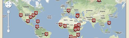
Crisis Mapping
On 11 March 2011, a catastrophic earthquake struck off the eastern coast of Japan, causing massive destruction and the deaths of over 16,000 people. Japanese news and aid agencies rushed to the area, but were only able to reach certain sectors. Some of the affected areas remained without media contact for up to a week. In these situations, geo-tagged tweets proved to be a key contact point between citizens and those trying to help. Some tweeted for food and supplies; others alerted news agencies to the fact that the noise of their helicopters flying overheard was hindering their ability to hear survivors' cries for help.
In crisis situations, the flexibility and rapid deployment of technological solutions is a big advantage, both to those on the ground and those watching from outside. A tool like Crisis Tracker, which aggregates tweets from crisis hotspots and displays them on an open source mapping platform, can be set up and running within hours (with current, albeit unverifiable, information). On the other hand, the popular crowdsourcing and mapping tool Ushahidi tends to focus more on user-submitted reports, which are of higher quality but take more time to process. iWitness, developed by Adaptive Path, is another, more intuitive real-time platform for tracking location-specific social media content.
Also working on technological solutions to disaster management is the Sahana Software Foundation, which produces a free and open source disaster management software suite called Eden that integrates functionality related to resource management and inventory, mapping, messaging and scenario planning.
Tips on using technology in crisis situations
- Have a set of trained volunteers on standby. Initiatives like Crisis Commons or New York's Code Corps brings together volunteer technologists who are ready to mobilise quickly in a disaster situation.
- Prepare for the worst. Expect some or all of your regular equipment or network infrastructure to be potentially non-functional, and have a contingency plan for this. Is your data backed up on a bootable hard-drive? Can your computer be attached to your mobile phone's internet connection in a pinch? Are you still able to operate if one or more platforms are inaccessible?
- Mobilise and communicate using technology, but don't forget the basics. Sahel Response was created shortly after drought hit the Sahel region in 2010, as a way to help visualise the areas that were the most in danger of famine. Information from the map was used for analytical purposes, but mainly to facilitate distribution of basic necessities like food and water.
Further Reading: Crisis Mapping
- Comparison of three free and open source software solutions for crisis situations from the Sahana Foundation
- Crisis Commons, a global network of volunteers that connects people and open source technology, and works towards better disaster response.


.png%3Fitok=rF0KWQB6)


.jpg%3Fitok=pXDTLHzY)


.jpg%3Fitok=3tJxk_zi)
.jpg%3Fitok=AIh9YY_n)


.jpg%3Fitok=1X702tBf)